
.svg)
Unofficial flag of Johnston Atoll, used to represent the island in a December 7, 2001 Pearl Harbor ceremony. The official flag of Johnston Atoll is the flag of the United States (also, the Kingdom of Hawaii claimed the island in the 1850s). The unofficial flag of Johnston Atoll was flown below the Stars and Stripes. The double bird holding 4 stars represents both the Air Force and the Fish and Wildlife Service, while the four stars denote the atoll's islands; the white is for coral and the aquamarine for the surrounding ocean.
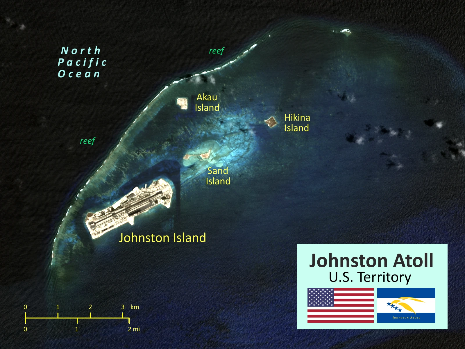
2016 satellite map of Johnston Atoll (Kalama Atoll).

Johnston Island Atoll
Johnston Island is part of the Pacific Remote Islands Marine National Monument, proclaimed by U.S. President George W. Bush on January 6, 2009. Johnston Island is a low sand and coral island, 717 miles West-South-West of Honolulu. It is roughly a mile and a half long by a half mile wide.
Overview[]
Johnston Atoll, also known as Kalama Atoll to Native Hawaiians, is an unincorporated territory of the United States currently administered by the United States Air Force of the United States Department of Defense.
Johnston Atoll is small, sandy Pacific Island that is a an unorganized (run by an pointed governor not an elected council), unincorporated territory (not officially part of the USA proper). The first Western record of the atoll was on September 2, 1796 when the Boston-based American brig Sally accidentally grounded on a shoal near the islands, but native Hawaiian fisherman had been visiting the island for centuries before them.
Johnston Atoll is an uninhabited 1,300 ha (3,200 acres) atoll in the North Pacific Ocean located about 750 nmi (860 mi; 1,390 km) southwest of the island of Hawaii and is grouped as one of the United States Minor Outlying Islands. The atoll, which is located on a coral reef platform, has four islands.
For nearly 70 years, the atoll was under the control of the American military. In that time it was used as a bird sanctuary, as a naval refueling depot, as an airbase, for nuclear and biological weapons testing, for space recovery, as a secret missile base, and as a chemical weapon and Agent Orange storage and disposal site. These activities left the area environmentally contaminated and remediation and monitoring continue.
Territorial stats[]
- Area: 6.92 km².
- Islands: 4.
- Population: 0 (2016), but there are occasional short term stays by American officials and the staff of a small American weather station.
- Currency: United States Dollar.
- Governing body: United States Fish and Wildlife Service.
The Island them selves[]
It is an uninhabited 1,300 ha (3,200 acres) atoll in the North Pacific Ocean located about 750 nmi (860 mi ; 1,390 km ) southwest of the island of Hawai'i and is grouped as one of the United States Minor Outlying Islands .The atoll, which is located on a coral reef platform, has four islands. Johnston (or Kalama) Island and Sand Island are both enlarged natural features, while Akau (to the North) and Hikina (to the East) are two artificial islands formed by coral dredging. By 1964, the dredge and fill operations had increased the size of Johnston Island to 596 acres (241 ha) from its original 46 acres (19 ha), also increased Sand Island from 10 to 22 acres (4.0 to 8.9 ha), and added two new islands, North and East, of 25 and 18 acres (10.1 and 7.3 ha).
The four islands compose a total land mass of 2.67 km². Due to the atoll's tilt, much of the reef on the southeast portion has subsided. But even though it does not have an encircling reef crest, the reef crest on the northwest portion of the atoll does provide for a shallow lagoon, with depths ranging from 3–10 m (9.8–32.8 ft).
The climate is tropical but generally dry. Northeast trade winds are consistent and there is little seasonal temperature variation. With elevation ranging from sea level to 5 m (16 ft) at Summit Peak, the islands contain some low-growing vegetation and palm trees on mostly flat terrain which has no natural fresh water resources present there save for the occasional post-rainstorm puddels near the areas of vegitation.
| Islands, | Size in 1942 (ha). | Final Size in 1964 (ha), | Used for burning and\or housing chemical weapons. |
|---|---|---|---|
| Johnston (Kalama) Island. | 19. | 241. | Yes. |
| Sand Island. | 4. | 9. | No. |
| North (Akau) Island. | Minimal. | 10. | No. |
| East (Hikina) Island. | Minimal. | 7. | No. |
| Total land area. | 23. | 267. | - |
| Johnston Atoll as a whole, including the lagoon. | 13,000. | 13,000. | - |
History[]

Johnston Atoll
Channel 7 news anchorman did a story on Johnston Island as it was closing down. The anchorman at one time worked on the island for Armed Forces Network.

President Nixon's Visit To Johnston Atoll (1969) Silent
National Archives and Records Administration PRESIDENT NIXON'S VISIT, JOHNSTON ISLAND, July 23-24, 1969 (no sound track).

Johnston Atoll HISTORY
Johnston Atoll HISTORY.

Remembering Johnston Island Atoll Revisited
Johnston Island is part of the Pacific Remote Islands Marine National Monument, proclaimed by U.S. President George W. Bush on January 6, 2009.

JohnstonIslandRecap
Some Pics put together towards the end of Johnston Island.
Discovery[]
The first Western record of the atoll was on September 2, 1796 when the Boston-based American brig Sally accidentally grounded on a shoal near the islands. The ship's captain, Joseph Pierpont, published his experience in several American newspapers the following year giving an accurate position of Johnston and Sand Island along with part of the reef. However, he did not name or lay claim to the area. The islands were not officially named until Captain Charles J. Johnston of the Royal Naval ship HMS Cornwallis sighted them on December 14, 1807. In the following years, an occasional vessel stopped, but generally one look was enough.
The Guano Islands Act is enacted[]
The Guano Islands Act, enacted on August 18, 1856, was federal legislation passed by the U.S. Congress that enabled citizens of the U.S. to take possession of islands containing guano deposits. In 1858 William Parker and R. F. Ryan, chartered the schooner Palestine specifically to find Johnston Atoll. They located guano on the atoll in March 1858 and they proceeded to claim the island under the Guano Islands Act. By 1858, Johnston Atoll was claimed by both the United States and the Kingdom of Hawaii.
In June 1858, Samuel Allen, sailing on the Hawaiian merchant vessel Kalama, tore down the U.S. flag and raised the Hawaiian flag renaming the atoll "Kalama". The larger island was renamed "Kalama Island", and the nearby smaller island was called "Cornwallis". The situation was resolved in favour of the USA after a few months.
The Guano eventually ran out in 1890.
1920s nature reserve[]
The Tanager Expedition was a joint expedition sponsored by the Department of Agriculture and the Bishop Museum of Hawaii and visited the Atoll in 1923. It became a federal nature preserve in 1926.
Annexation to the USA[]
On December 29, 1934, President Franklin D. Roosevelt with Executive Order 6935 transferred control of Johnston Atoll to the United States Navy under the 14th Naval District, Pearl Harbor, in order to establish an air station, and also to the Department of the Interior to administer the bird refuge. In 1948 the U.S Air Force assumed control of the Atoll.
Sand Island seaplane base[]
In 1935 personnel from the US Navy's Patrol Wing Two carried out some minor construction to develop the atoll for seaplane operation. In 1936, the Navy began the first of many changes to enlarge the atoll's land area. They erected some buildings and a boat landing on Sand Island and blasted coral to clear a 3,600 feet (1,100 m) seaplane landing.
Several seaplanes made flights from Hawaii to Johnston, such as that of a squadron of six aircraft in November, 1935. One of the most spectacular of these was on April 8, 1937, when two VP-6's made the round trip in ten and a half hours, to bring back a sick seaman.
World War 2[]
USAF base[]
Atomic tests[]
Atomic tests like Operation Hardtack I high-altitude nuclear test and Operation Fishbowl high-altitude nuclear test took place here.
Johnston Island Launch Emplacement One (LE1)[]
Operation Bluegill Prime[]
[]
Baker-Nunn satellite tracking camera station[]
Johnston Island Recovery Operations Center[]
Biological warfare test site in 1965[]
Space tech[]
The 'Scientific Row' area[]
Program 437 (PGM-17 Thor anti-satellite (ASAT) weapon system)[]
Chemical weapons unit[]
On 31 July 2001 the U.S. Army Chemical Activity Pacific retired its colors on Johnston Island, shortly after which and the storage and destruction facility was cleaned out and abandoned.
On January 6, 2009, President George W. Bush issued Executive Order 8836, establishing Pacific Remote Islands Marine National Monument to preserve the marine environments around Wake Atoll, Baker Island, Howland Island, and Jarvis Islands, Johnston Atoll, Kingman Reef, and Palmyra Atoll.
Chemical weapon storage[]
Agent Orange storage[]
Operation Pacer HO[]
Modern day nature reserve[]
Johnston Atoll Chemical Agent Disposal System (JACADS) building[]
Small pier, weather station and tool shed.[]
Legacy[]
Johnston Island is part of the Pacific Remote Islands Marine National Monument, proclaimed by U.S. President George W. Bush on January 6, 2009.
Residual agent orange, Plutonium, PCB, oil and asbestos pollution is checked periodically by government officials.
Also see[]
- Nukes
- Islands
- Wake Atoll
- Bikini Atoll
- Vietnam War
- Midway Island
- Nuclear fallout
- Tern Island Airstrip
- Manganese nodules
- Noteworthy Air bases
- Geiger-Muller counter
- French Frigate Shoals
- Hardtack Teak high-altitude nuclear test
- Starfish Prime high-altitude nuclear test
- Operation Dominic high-altitude nuclear test
- Operation Fishbowl high-altitude nuclear test
- Operation Hardtack I high-altitude nuclear test
- A nuclear\atomic holocaust or nuclear apocalypse
- Directory of all Indochinese wars in the Cold War
- Life and death in the lesser colonies (Attempted nuclear war simulation)
Links[]
- http://en.wikipedia.org/wiki/Johnston_Atoll
- http://en.wikipedia.org/wiki/Starfish_Prime
- http://en.wikipedia.org/wiki/High-altitude_nuclear_explosion
- http://www.globalsecurity.org/wmd/facility/johnston_atoll.htm
- https://en.wikipedia.org/wiki/Johnston_Atoll
- http://www.urbanghostsmedia.com/2010/04/isolated-and-abandoned-military-airbase-johnston-atoll/
- http://www.thelivingmoon.com/45jack_files/03files/Johnston_Atoll.html
- http://www.urbanghostsmedia.com/2010/04/isolated-and-abandoned-military-airbase-johnston-atoll/
- http://www.classbrain.com/cb_cr/fields/natural_resources.html