
Kure atoll Coast Guard Loran Station HI
A collection of picture from my first duty station, Kure Island, Hawaii.

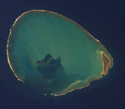
The atoll seen from the air. hallow Circle Reef, Green Island and the interior's underwater silting-up are visible.
Overview[]
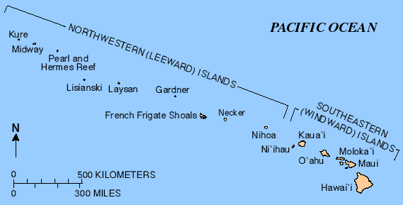
A map showing the location of Kure Atoll in the Hawaiian island chain.
Kure Atoll (/ˈkʊəriː/; Hawaiian: Mokupāpapa) or Ocean Island is an atoll in the Pacific Ocean 48 nautical miles (89 km; 55 mi) beyond Midway Atoll in the Northwestern Hawaiian Islands at 28°25′N 178°20′W, coordinates: 28°25′N 178°20′W. The only land of significant size is called Green Island and is habitat for hundreds of thousands of seabirds. A short, unused and unmaintained runway and a portion of one building, both from a former United States Coast Guard LORAN station, are located on the island. Politically it is part of Hawaii, although separated from the rest of the state by Midway, which is a separate unorganized territory. The International Date Line lies approximately 100 miles (87 nmi/160 km) to the west. Surprisingly, although located to the west of Midway Atoll, Kure Atoll has a timezone +1 hour ahead at UTC-10:00 (the same as the rest of Hawaii).
Geography[]
Kure is the northern-most coral atoll in the world. It consists of a 6-mile (10 km) wide nearly circular barrier reef surrounding a shallow lagoon and several sand islets. There is a total land area of 213.097 acres (86.237 ha), with Green Island on the southeast side having 191.964 acres (77.685 ha) of this total. Kure Atoll features a tropical savanna climate (Köppen Aw) with very pleasant year-round temperatures. Rainfall is evenly distributed throughout the year, with only two months being able to be classified as dry season months (May and June).
Stats[]
The total land area is 0.862 km2 (0.333 sq mi) of sand and coral.
- Green Island ~80% of the land mass.
- Shallow Reef Patch.
- Sand Island.
- Dispersing or Disappearing Island\Sand Bank.
- Shallow Reef\Shallow Circle Reef\Shallow Perimeter Reef ~10% of the land mass.
Green Island is the only permanent island in the atoll, all the others are covered by the sea during high tide.
The lagoon is slowly silting up. The atoll's highest point is 20 feet (6 m) above sea level.
Geological history[]
The geological history of Kure is generally similar to Midway, but Kure lies close to what is called the Darwin Point, the latitude at which reef growth just equals reef destruction by various physical forces. As Kure continues to be slowly carried along to the northwest by the motion of the Pacific Plate, it will move into waters too cool for coral and coralline algae growth to keep up with isostatic subsidence of the mountain. Barring unforeseen evolution, it will then begin to join the other volcanic and reef-topped remnants of the Hawaiian-Emperor Chain to the northwest, all of which are now seamounts.
Rubbish heaps[]
Kure is located within a major current which washes up debris from the Great Pacific Garbage Patch, such as fishing nets and large numbers of cigarette lighters, on the island. These pose threats to the local animals, especially birds, whose skeletons are frequently found with plastic in the stomach cavity.
History[]
Pre-1886[]
In the Hawaiian language the term Mokupāpapa was used for any flat island with reefs. The northwestern islands are associated with Kāne Milohai in Hawaiian mythology. The brother of Pele (creator of the islands) was left to stand guard for travelers. Native Hawaiian fishermen probably would have visited it on occasion, as had the native person who found the island of 'Mokupāpapa'.
Before the mid-19th century, Kure Atoll was visited by several ships and given new names each time. Sometimes spelled Cure, its English name was for a Russian navigator who sighted the atoll.
1886-Word War 2[]
Many crews were stranded on Kure Atoll after being shipwrecked on the surrounding reefs and had to survive on the local seals, turtles, and birds. The shipwrecks remain on the reef today, including the USS Saginaw. Because of these incidents, King Kalākaua sent Colonel J. H. Boyd to Kure as his Special Commissioner. On September 20, 1886, he took possession of the island for the Hawaiian government. The King ordered that a crude house be built on the island, with tanks for holding water and provisions for any other unfortunates who might be cast away there. But the provisions were stolen within a year and the house soon fell into ruins. It was officially named Kure Island in 1924 and then Kure Atoll in 1987.
World War 2[]
Largely neglected for most of its history, during World War II Kure was routinely visited by U.S. Navy patrols from nearby Midway to ensure that the Japanese were not using it to refuel submarines or flying boats from submarine-tankers for attacks elsewhere in the Hawaiian chain. During the Battle of Midway, a Japanese Nakajima B5N "Kate" bomber, operating from aircraft carrier Hiryū, piloted by Lieutenant Kikuchi Rokurō, and which had been involved in the initial Japanese attack on Midway's US installations, crash-landed near Kure after being damaged by US fighters. Once ashore, Lt. Kikuchi and the two other members of his crew (Warrant Officer Yumoto Noriyoshi and Petty Officer (1st Class) Narasaki Hironori) refused capture and were either killed or committed suicide when an American landing party tried to capture them.
Cold War[]
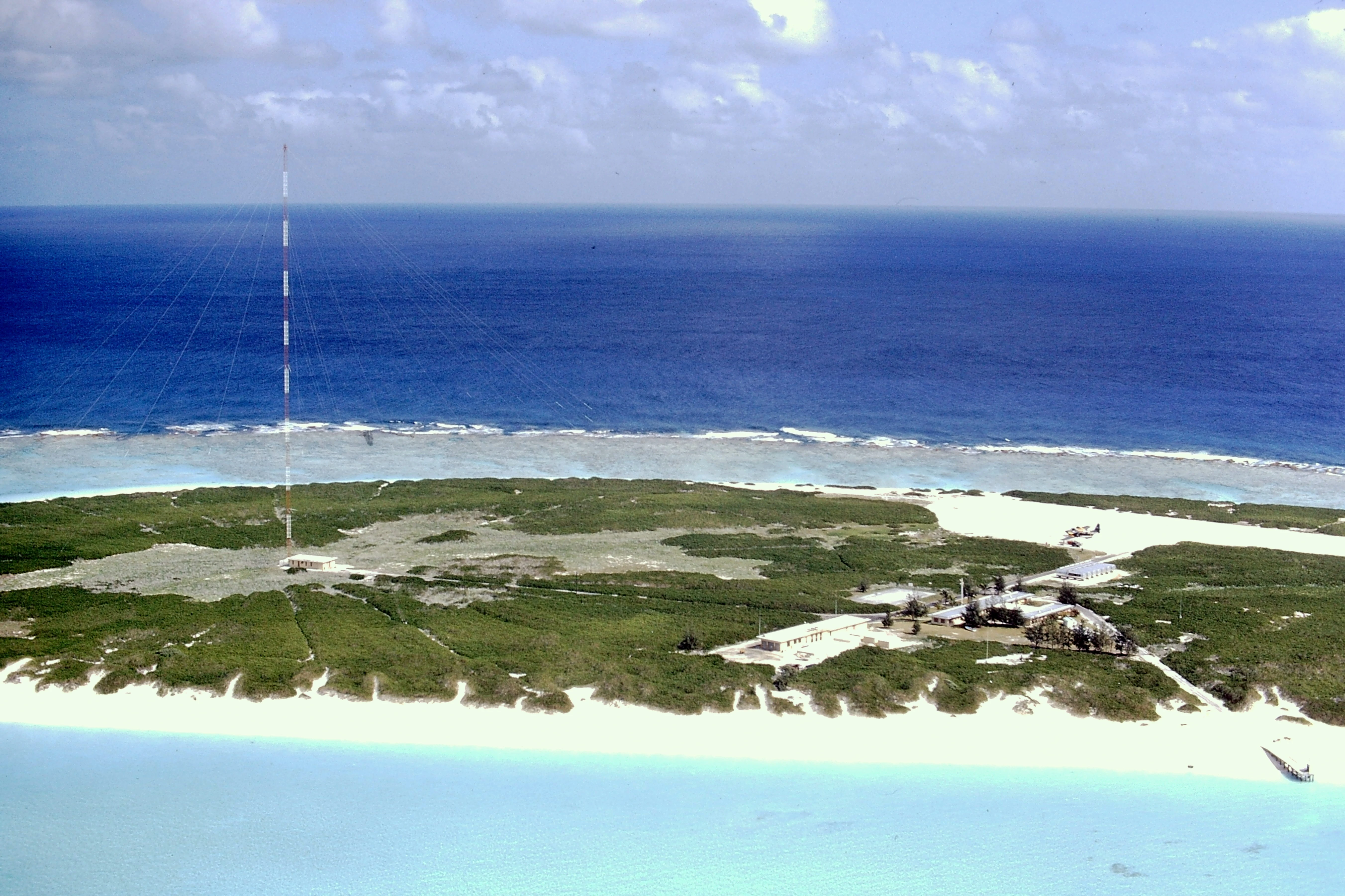

The United States Coast Guard LORAN station at Kure in 1971. Attribution: Jigreenberg at English Wikipedia.
From 1960 to 1992, a United States Coast Guard LORAN station was located on Green Island.
Post-Cold War[]
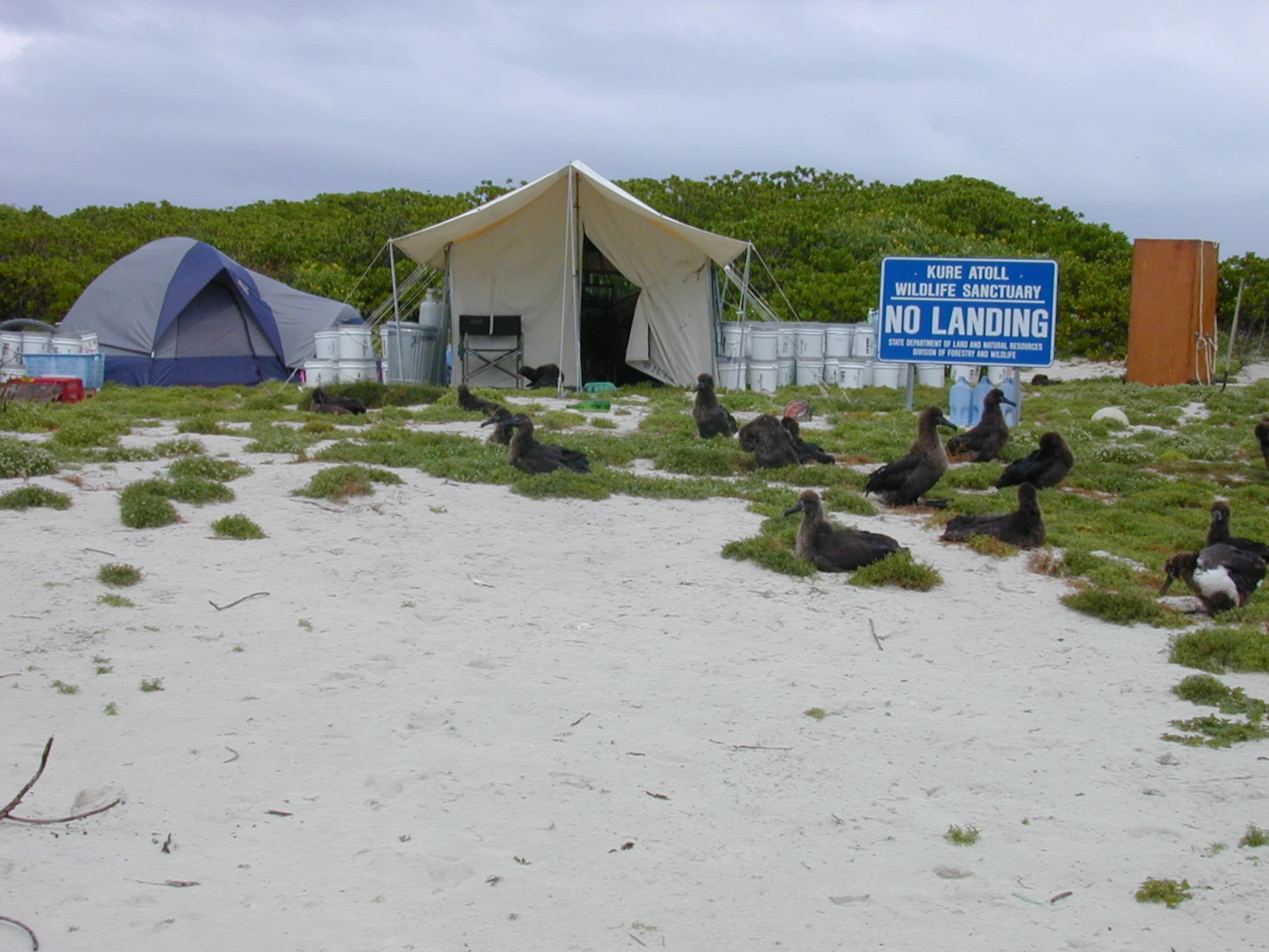

Volunteer tents and albatrosses at Kure. Attribution: Forest & Kim Starr.
On October 16, 1998, the longline fishing vessel Paradise Queen II ran aground on the eastern edge of Green Island of Kure Atoll, spilling approximately 4,000 gallons of diesel fuel before recovery operations could commence. Debris from that shipwreck continued to pollute the reef and shoreline for many years, endangering wildlife and damaging the coral reef. The long-term impact of this and other wrecks within the Northwestern Hawaiian Islands (NWHI) highlight the dangers to sensitive habitats in the area. To help ensure their protection, the Papahānaumokuākea Marine National Monument was designated a Particularly Sensitive Sea Area (PSSA) in 2008 by the International Maritime Organization. In addition to avoiding specific areas, owners must identify when their ship enters and leaves the PSSA's 10 nautical mile wide reporting area so a timely response can be taken should there be a maritime emergency.
LORAN station[]
The United States Coast Guard LORAN station at Kure in 1971
From 1960 to 1992, a United States Coast Guard LORAN station was located on Green Island. A short coral runway was built on the island to support Coast Guard operations, but it was abandoned and is currently unusable. Although there is no permanent human population, the atoll is formally part of the City and County of Honolulu. It became a state wildlife sanctuary in 1981. Since 1993 the Hawaii Department of Land and Natural Resources and volunteers from the Kure Atoll Conservancy group have helped to restore the atoll to a more natural state. Jean-Michel Cousteau produced a video on a voyage to Kure which first aired in 2006. Since 2010 the Division of Forestry and Wildlife has had a year-round presence on Kure Atoll. The small airstrip is now derilict and out of use, as are the 2 LORAN station buildings, but not the visitor's toolshed.
Gallery[]
")
")
_(20159194319).jpg "Atoll research bulletin (1972) (20159194319).jpg (1.18 MB)")
")
Nature reserve[]
In 1909, President Theodore Roosevelt made Kure Atoll part of the Hawaiian Islands Bird Reservation, run by the Department of Agriculture as a preserve for native birds. Midway Atoll, French Frigate Shoals and Kure Atoll (the latter 2 are officially part of Hawaii State) are part of the Papahānaumokuākea Marine National Monument\Northwestern Hawaiian Islands National Monument of the United States in 2006.
See also[]
- Wake Atoll
- Midway Island
- Johnston Atoll
- French Frigate Shoals
- French Frigate Shoals Airport
- Trust Territory of the Pacific Islands
Sources[]
- http://hawaiianatolls.org/about/kure.php
- https://en.wikipedia.org/wiki/Kure_Atoll
- https://images.search.yahoo.com/search/images;_ylt=AwrBT7mh89FYblUAfptXNyoA;_ylu=X3oDMTEydWxicGdtBGNvbG8DYmYxBHBvcwMxBHZ0aWQDQjM2MDRfMQRzZWMDc2M-?p=Kure+Atoll&fr=yset_chr_cnewtab
- http://www.papahanaumokuakea.gov/visit/kure.html
- http://www.to-hawaii.com/kureatoll.php
- https://video.search.yahoo.com/search/video;_ylt=AwrBT7mh89FYblUAiZtXNyoA;_ylu=X3oDMTEyNHBvaXRwBGNvbG8DYmYxBHBvcwMyBHZ0aWQDQjM2MDRfMQRzZWMDc2M-?p=Kure+Atoll&fr=yset_chr_cnewtab
- http://pubs.usgs.gov/of/2012/1182/of2012-1182.pdf