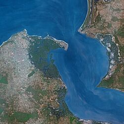
A satellite image of Banjul, Gambia.

A satellite image of Gambia.
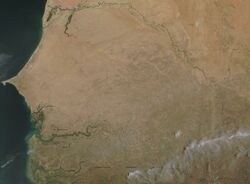
A dry season image of Senegal and Gambia.
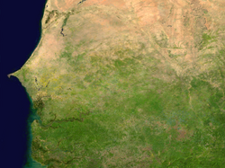
A wet season image of Senegal and Gambia.
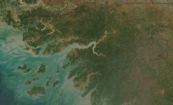
A satellite image of Guinea-Bissau.
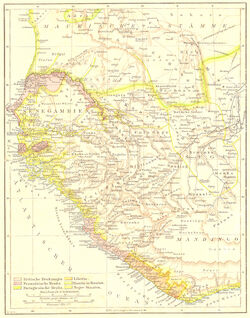
A 1881 colonial map of Gambia, Guinea Bissau, Senegal, Sierra Leonine, Liberia and the native tribal states like the Bamiko (Bamako) state.
Links to various historic maps of Africa.
- http://etc.usf.edu/maps/pages/800/870/870.htm
- http://etc.usf.edu/maps/pages/000/32/32.htm
- http://etc.usf.edu/maps/pages/7300/7338/7338.pdf
- http://etc.usf.edu/maps/pages/7600/7638/7638.htm
- http://etc.usf.edu/maps/pages/7600/7638/7638.htm
- http://etc.usf.edu/maps/pages/7600/7638/7638.htm
- http://etc.usf.edu/maps/pages/6700/6741/6741.htm
- http://etc.usf.edu/maps/pages/6700/6741/6741z.htm
- http://etc.usf.edu/maps/pages/6700/6741/6741.htm
- http://etc.usf.edu/maps/pages/5300/5338/5338.htm
- http://etc.usf.edu/maps/pages/4800/4873/4873.htm
- http://etc.usf.edu/maps/pages/7400/7481/7481.htm
- http://www.globalsecurity.org/military/world/war/images/africa_1890.jpg
- https:://cbertel.files.wordpress.com/2009/09/africa-colonial-map.jpg
- http://www.britishempire.co.uk/images4/africa1885map.jpg
- https:://i0.wp.com/dexterrobinson.com/wp-content/uploads/2016/12/cropped-Scramble-for-Africa-1880-1913.jpg
- https:://userscontent2.emaze.com/images/67f976c4-033e-4991-bf8f-a17e64301fb8/22f43d3c52ad1cb92c9a089377e06a68.jpg
- https://dexterrobinson.com/africa-before-scramble-for-africa/
- http://www.globalsecurity.org/military/world/war/images/africa_1890.jpg
- http://en.wikipedia.org/wiki/File:Territorial_growth_of_Libya_during_the_Italian_period.jpg
- http://www.globalsecurity.org/military/world/war/scramble-for-africa-maps-2.htm
- http://www.globalsecurity.org/military/world/war/images/map-1625.jpg
- https://en.wikipedia.org/wiki/Voulet%E2%80%93Chanoine_Mission
- https://dexterrobinson.com/africa-before-scramble-for-africa/
- https://en.wikipedia.org/wiki/Scramble_for_Africa
- https://commons.wikimedia.org/wiki/File:Scramble-for-Africa-1880-1913.png
- https://dexterrobinson.com/africa-before-scramble-for-africa/
- http://www.zum.de/whkmla/histatlas/westafrica/haxmali.html
- http://www.lib.utexas.edu/maps/historical/history_africa.html
- http://www.lib.utexas.edu/maps/historical/africa_1890.jpg
- http://www.africafederation.net/Lunda_Tchockwe.htm
- http://www.africafederation.net/Lunda_Muatianvua_1890.jpg
- http://www.gifex.com/detail-en/2010-01-05-11631/Africa-in-1880.html
- http://www.gifex.com/images/500X0/2010-01-05-11631/Africa-in-1880.jpg
Also see
- 1880's-1910's Brazilian notes.
- Atomic warfare information notes.
- Baltics are Waking Up
- Cold War secret police organisations
- Estonia did have a submarine in 1937!
- How Governments become Authoritarian
- Lithuanian did have a navy, army air-force and natural resources in 1933!
- Minerals and fuel in central Africa
- Nations and vassal states of 1490-1500
- Nations in 1988
- Nations in 1991
- O.T.L. history notes
- OTL Decolonisation notes
- OTL Natural disasters
- Singing Revolution
- The "Baltic Chain" demonstration on August 23, 1989
- The O.T.L. Operation High Jump conspiracy theory
- The Swiss National Redoubt (1880-2010)
- Today's OTL types of economies, societies and regimes
- UK and Commonwealth OTL troop numbers in WW1
- UK and Commonwealth OTL troop numbers in WW2
- UK OTL atomic reactors in 1962
- What is a coup d'état?
- Why the USSR broke up in reality