
MIDWAY V - A bike ride around Midway Island
Jan takes you on a bike ride around Midway Island. Here you will get to see just how many Albatrosses nest on this little island. To view the exact bicycle route from this video, you can download the Google Earth KML file here: http://www.copperskyproductions.com/midway/gps/midwayisland-bikeride-1.kml Music by: Graham Ord featuring Tim Stewart Chief - from the album Waiting http:///www.GrahamOrd.com
Overview[]
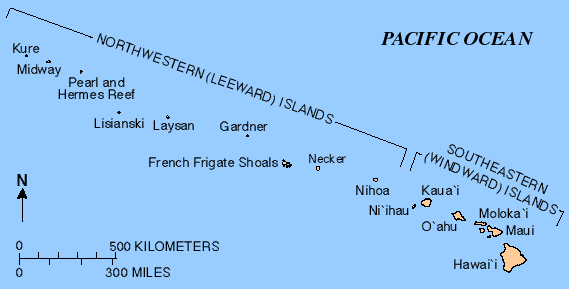
Map showing the location of Midway Atoll in the Hawaiian island chain.

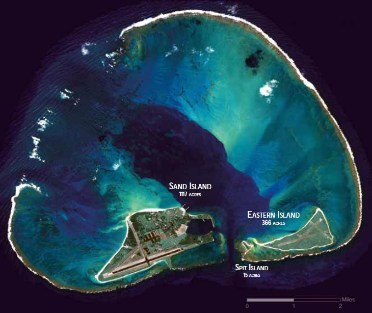
Satellite image of Midway Atoll.
Midway Atoll (/ˈmɪdweɪ/; also called Midway Island and Midway Islands; Hawaiian: Pihemanu Kauihelani) is a 2.4-square-mile (6.2 km2) atoll in the North Pacific Ocean at 28°12′N 177°21′W.
Midway Island is small, sandy Pacific Island that is a an unorganized (run by an pointed governor not an elected council), unincorporated territory (not officially part of the USA proper). The atoll was sighted on July 5, 1859, by Captain N.C. Middlebrooks, commonly known as Captain Brooks, of the sealing ship Gambia,, but native Hawaiian fisherman had been visiting the island for centuries before them.
Name[]
As its name suggests, Midway is roughly equidistant between North America and Asia, and lies almost halfway around the world longitudinally from Greenwich, UK. It is near the northwestern end of the Hawaiian archipelago, about one-third of the way from Honolulu, Hawaii, to Tokyo, Japan.
Midway Atoll is less than 140 nautical miles (259 km; 161 mi) east of the International Date Line, about 2,800 nautical miles (5,200 km; 3,200 mi) west of San Francisco, and 2,200 nautical miles (4,100 km; 2,500 mi) east of Tokyo.
The Midway Island group.[]
| Island. | acres. | hectares. |
|---|---|---|
| Sand Island. | 1,200. | 486. |
| Eastern Island. | 334. | 135. |
| Spit Island. | 6. | 2. |
| Midway Atoll. | 1,540. | 623. |
| Lagoon (the naturally formed lake inside the island group). | 14,800. | 6,000. |
History[]
Pre WW2[]
The atoll was sighted on July 5, 1859, by Captain N.C. Middlebrooks, commonly known as Captain Brooks, of the sealing ship Gambia. The islands were named the "Middlebrook Islands" or the "Brook Islands". Brooks claimed Midway for the United States under the Guano Islands Act of 1856, which authorized Americans to occupy uninhabited islands temporarily to obtain guano. There is no record of any attempt to mine guano on the island. On August 28, 1867, Captain William Reynolds of the USS Lackawanna formally took possession of the atoll for the United States; the name changed to "Midway" some time after this. The atoll was the first Pacific island annexed by the United States, as the Unincorporated Territory of Midway Island, and was administered by the United States Navy.
The first attempt at settlement was in 1871, when the Pacific Mail Steamship Company started a project of blasting and dredging a ship channel through the reef to the lagoon using money put up by the United States Congress. The purpose was to establish a mid-ocean coaling station to avoid the high taxes imposed at ports controlled by the Hawaiians. The project was shortly a complete failure, and the USS Saginaw evacuated the last of the channel project's work force in October 1871. The ship ran aground at Kure Atoll, stranding everyone. All were rescued, with the exception of four of the five persons who sailed to Kauai in an open boat to seek help.
WW2[]
The island was of major strategic importance and the gateway to the Hawwain island chain. The Battle of Midway occurred btween the USA and Imperial Japan on 4–7 June 1942.
Cold War[]
Korean and Vietnam Wars[]
From August 1, 1941 to 1945, it was occupied by U.S. military forces. In 1950, the Navy decommissioned Naval Air Station Midway, only to re-commission it again to support the Korean War. Thousands of troops on ships and aircraft stopped at Midway for refueling and emergency repairs. From 1968 to September 10, 1993, Midway Island was a Naval Air Facility.
During the Cold War, the U.S. established an underwater listening post at Midway to track Soviet submarines. The facility remained secret until its demolition at the end of the Cold War. U.S. Navy WV-2 (EC-121K) "Willy Victor" radar aircraft flew night and day as an extension of the Distant Early Warning Line, and antenna fields covered the islands.
With about 3,500 people living on Sand Island, Midway also supported the U.S. troops during the Vietnam War. In June 1969, President Richard Nixon held a secret meeting with South Vietnamese President Nguyen Van Thieu at the Officer-in-Charge house or "Midway House".
The Japanese trawler Houei Maru #5 sunk on the atoll in 1976, with the loss of 17 crewmembers. About 50% of the ship's hull remains there as a rusted wreck.
Civilian handover[]
In 1978, the Navy downgraded Midway from a Naval Air Station to a Naval Air Facility and large numbers of personnel and dependents began leaving the island. With the war in Vietnam over, and with the introduction of reconnaissance satellites and nuclear submarines, Midway's significance to U.S. national security was diminished. The World War II facilities at Sand and Eastern Islands were listed on the National Register of Historic Places on May 28, 1987 and were simultaneously added as a National Historic Landmark.
As part of the Base Realignment and Closure process, the Navy facility on Midway has been operationally closed since September 10, 1993, although the Navy assumed responsibility for cleaning up environmental contamination at Naval Air Facility Midway.
.
Post-Cold War[]
.
Nature reserve[]
Midway Atoll, French Frigate Shoals and Kure Atoll (the latter 2 are officially part of Hawaii State) are part of the Papahānaumokuākea Marine National Monument\Northwestern Hawaiian Islands National Monument of the United States in 2006.
It is also a
Air strip and former military base[]
Henderson Field was a airbase on the island. Sand Island's Henderson Field is both the islands uncontrolled (no air traffic control unit) airport and an emergency diversion point runway for transpacific flights. It was created during the cold war and
Eastern Island Airstrip (originally also called "Henderson" before the new airport was built) is a disused airfield that is mostly constructed of Marston Mat and was built by the United States Navy Seabees (a part of the USN's core of engineer). It saw use in the Battle of Midway. During the Cold War it was
Population[]
About 40 to 60 people live on the atoll, which includes staff of the US Fish and Wildlife Service and related contract workers. It has no fixed population since the last 4 islanders left in 2000.
Also see[]
Sources[]
- http://www.classbrain.com/cb_cr/fields/natural_resources.html
- https://video.search.yahoo.com/search/video;_ylt=A0LEV0OQPbNYeKMAdshXNyoA;_ylu=X3oDMTEyNnB0NGkzBGNvbG8DYmYxBHBvcwMyBHZ0aWQDQjM0MjhfMQRzZWMDc2M-?p=midway+island&fr=yset_chr_cnewtab
- https://www.britannica.com/place/Midway-Islands
- http://www.midwayisland.com/
- http://www.midway-island.com/
- https://en.wikipedia.org/wiki/Midway_Atoll
- https://en.wikipedia.org/wiki/Henderson_Field_(Midway_Atoll)
- http://www.midway-island.com/
- http://www.midwayisland.com/
- https://www.wikiwand.com/en/Battle_of_Midway
- http://tps.cr.nps.gov/nhl/detail.cfm?ResourceId=2005&ResourceType=District
- https://www.skyscanner.net/airports/ipc/easter-island-airport.html
- http://wikimapia.org/9762510/Eastern-Island-Airstrip
- https://coast.noaa.gov/data/Documents/OceanLawSearch/Papahanaumokuakea%20Submission%20to%20IMO%20for%20Designation%20as%20Particularly%20Sensitive%20Sea%20Area%20(April%205%2C%202007).pdf